
On Fri, Feb 20, 2009 at 7:50 PM, Ben Konrath <ben@bagu.org> wrote:
I just discovered the "human made area" Garmin polygon (0x13) which seems to be a better choice for these pedestrian squares. An updated patch is attached. Let me know how it works for you.
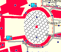
Hm... this polygon type (0x13) is not documented in the garmin_feature_list.csv file in the mkgmap resources directory, is it? Where did you find it? I tried out a somewhat different approach for for squares and plazas: I found an unused polygon type (0x1b) and added a tiled bitmap for this polygon to the TYP file I use. The bitmap, with a lot of imagination, represents what I could picture as a flagstoned or cobblestoned area. As well, I added 0x1b to my polygon style file. I have attached a Mapsource screen shot of the result. The screen shot is of Piazza San Pietro in Vatican City. Personally, I think this looks rather nice, but that is a matter of taste and politics. ;-) However, I'm not sure what consequences these polygon types would have for pedestrian/bicycle routing. It would be inconvenient if pedestrians were always routed around plazas and squares as if these areas were impassible obstacles. Cheers.