
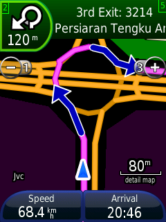
This behavior is "correct" with maps created with cgpsmapper (including those at mapcenter2). Only last week they found a breakthrough on this - http://malfreemaps.com/viewtopic.php?p=22936#p22936. I'm not sure if Stan has released the updated version of cgpsmapper yet. Another problem solved is the left-hand traffic roundabout display issue on Nuvi and MobileXT (see attached pic) http://malfreemaps.com/viewtopic.php?p=26047#p26047. Not sure if this also correctly identify "u-turn" as opposed to "turn-right, turn-right" instruction. nyem Steve Hosgood wrote:
Paul Ortyl wrote:
I do confirm that too (Nüvi 660T).
Paul
I raised a comment about this quite a while back on the Wiki pages for mkgmap. As far as I've seen, no-one has the faintest idea what's going on. I postulated that street widths ought to be a variable setting in Garmin's routable-map files, but it seems no-one's yet worked out how to set it.
A question please: does anyone know if the behaviour is "correct" with maps built using the 'cGPSmapper' program or the http://mapcenter.cgpsmapper.com/ web-page that provides an online version of its functionality? I've never been able to get this page to work for me - has anyone else been luckier?
Steve