
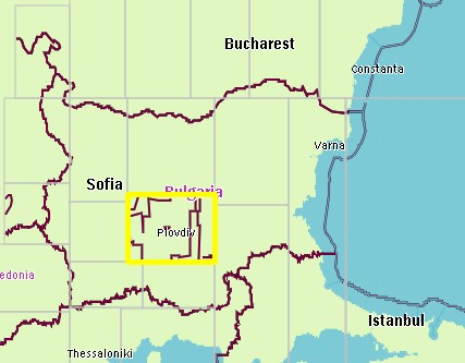
I did some other tests, the geofabrik extract from Bulgaria didnt show those "borders", maybe because the international boundaries were incomplete. I also downloaded the border relation from Bulgaria as well as rel.1338717 (bg.osm) and process this file with mkgmap 2479, there were no issues at all. In my first testmap I used the europe extract, and the strange thing is that not all ways from rel. 1338717 were converted into borders but only in one tile, see attachment. So maybe it is related to the splitter keep-complete process in combination with r2478? I have uploaded this tile for further analysis: http://mijndev.openstreetmap.nl/~ligfietser/test/10133095.zip http://mijndev.openstreetmap.nl/~ligfietser/test/bg.osm The splitter coordinates are 10133095: 1951744,1124352 to 1990656,1206272 # : 41.879883,24.125977 to 42.714844,25.883789
I see on my maps that all ways from http://www.openstreetmap.org/browse/relation/1338717 are rendered as country border now (mkgmap r-2479)
This relation contains only two tags: name = Hires coverage of Bing in Bulgaria type = multipolygon
No other tags, and yet it gets a admin_level=2 somehow. I think the relation contains ways with admin_level2 borders and gets 'contamined' with those tags.
Tested it with the default styles as well as mine, both render all those lines as international border. In mkgmap r2459 those lines were not rendered at all (as it should be), so i think there is a serious bug here.
I also get marine borders at some borders inland now (tagged with maritime=yes but they dont have those tags at all).
Use outer polygon tags if the multipolygon is tagged with name only
Quite a lot of mps are errorneously tagged with name only. This was ignored by the mp algorithm some time ago but at any point of time it disappeared. Fixing that now.
mkgmap-dev mailing list mkgmap-dev@lists.mkgmap.org.uk http://lists.mkgmap.org.uk/mailman/listinfo/mkgmap-dev