
I don't think this can be improved. As I understand it, internally Garmin devices hold coordinates in the number of bits specified in the level. So 24 bits has a resolution of 2.4 metres, 23 bits has a resolution of 4.8 meters and so on. If you look carefully, all the vertices of the lines lie on a square grid. Having said that, that must be a very steep slope - unless something else is creating the granularity. On Fri, 23 Apr 2021 at 12:06, <mkgmap-dev-request@lists.mkgmap.org.uk> wrote:
Send mkgmap-dev mailing list submissions to mkgmap-dev@lists.mkgmap.org.uk
To subscribe or unsubscribe via the World Wide Web, visit https://www.mkgmap.org.uk/mailman/listinfo/mkgmap-dev or, via email, send a message with subject or body 'help' to mkgmap-dev-request@lists.mkgmap.org.uk
You can reach the person managing the list at mkgmap-dev-owner@lists.mkgmap.org.uk
When replying, please edit your Subject line so it is more specific than "Re: Contents of mkgmap-dev digest..." Today's Topics:
1. Resolution 23 raster problems (Felix Hartmann)
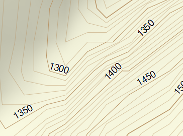
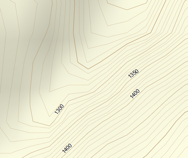
---------- Forwarded message ---------- From: Felix Hartmann <extremecarver@gmail.com> To: Development list for mkgmap <mkgmap-dev@lists.mkgmap.org.uk> Cc: Bcc: Date: Fri, 23 Apr 2021 18:01:15 +0800 Subject: [mkgmap-dev] Resolution 23 raster problems Any ideas why this is happening? Some of the contourlines intersect each other at resolution 23 - I especially used reduce-point-density=1.0 to try to stop it.
java -jar -Xmx47000M /home/contourlines/mkgmap.jar --keep-going --dem-poly=/home/contourlines/bounds/bayern.poly --series-name=openmtbmap-cntrs-DBY-23-Apr-2021 --dem=/home/contourlines/hgt/VIEW1/,/home/contourlines/hgt/SRTM1v3.0,/home/contourlines/hgt/VIEW3/,/home/contourlines/hgt/SRTM3v3.0/ --dem-dists=5520 --max-jobs=7 --reduce-point-density=1 --transparent --style-file=srtm24 --latin1 95260000.osm.pbf
Is there any way to improve this?
Look at the screenshots - the small one is resolution 23, the big one 24. If using 10m interval contourlines this is pretty obviously not ideal. Resolution 24 could be nicer - but I guess this is more a problem of phyghtmap (while groundtruth can produce higher quality), but resolution 23 really becomes confusing vs 24...: [image: Simplification_23.PNG] [image: Oiginal_24.PNG]
If pictures don't show https://openmtbmap.org/23.PNG https://openmtbmap.org/24.PNG -- Felix Hartman - Openmtbmap.org & VeloMap.org
_______________________________________________ mkgmap-dev mailing list mkgmap-dev@lists.mkgmap.org.uk https://www.mkgmap.org.uk/mailman/listinfo/mkgmap-dev