
On 08.12.2009 10:42, Marko Mäkelä wrote:
Hi Mark,
The default style-file of course should have something like below:
highway=*& (surface=unpaved | surface=dirt | surface=sand | surface=ground | surface=gravel | tracktype=grade2 | tracktype=grade3 | tracktype=grade4 | tracktype=grade5 | sac_scale=* | smothness= ........) {add unpaved=yes}
Felix echoes my thoughts exactly. There's lot's of surface values that imply unpavedness so using surface=unpaved isn't the way to go. I did wonder about using a mkgmap specific tag, e.g. mkgmap:unpaved=yes but as unpaved=yes (or paved=no) do not obviously conflict with existing OSM tags, I thought I would not use the mkgmap: prefix.
http://wiki.openstreetmap.org/wiki/Proposed_features/surface_unification suggests surface:material, but then again, surface:material=asphalt, surface:condition!=maintained can be worse than some surface:material=gravel.
It seems best to introduce a mkgmap:paved tag that can be translated into by style files.
If people are happy with that, I will commit the patch soon as it is.
For what it is worth, I tried your v2 patch with the following, but I was unable to convince my Edge 705 to suggest using a forest path that it used to suggest until some weeks ago. (In other words, it avoided the unpaved roads no matter what the routing preference was.)
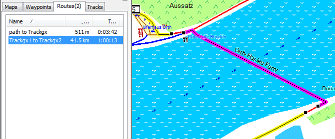
-- It makes not much sense to test like you do. You should build a testmap in JOSM and then do the testing to check whether it works or not. If a road is added as paved=no, then it will not be choosen at all even if it is much much shorter if you block it. Just like toll=yes. This is different to blocking something with motorcar=no, here it will block less strictly (only blocks as via, no blocking as terminal road). See for example this this picture. If I add the unpaved tag to a ferry (or the toll tag, both works) it will be avoided at all cost (yellow). If not it is a mere 511m trip (I put in a little difference so it is easier to differentiate the routes): Now here it is able to calculate a different route. If this were not possible, and only blocked via motorcar=no it would be used nevertheless. As toll or unpaved it will never be used if prohibited so no route at all will be found if no detour is possible.
Index: resources/styles/default/points =================================================================== --- resources/styles/default/points (revision 1420) +++ resources/styles/default/points (working copy) @@ -1,3 +1,6 @@ +surface=unpaved|surface=ground|surface=grass|surface=gravel|surface=sand|surface=unsurfaced|mtb:scale=* { add paved=no } +surface=paved|surface=asphalt { add paved=yes } + #aeroway=airport [0x5900 resolution 20] aeroway=airport [0x2f04 resolution 20] aeroway=aerodrome [0x2f04 resolution 20]
Best regards,
Marko _______________________________________________ mkgmap-dev mailing list mkgmap-dev@lists.mkgmap.org.uk http://www.mkgmap.org.uk/mailman/listinfo/mkgmap-dev