
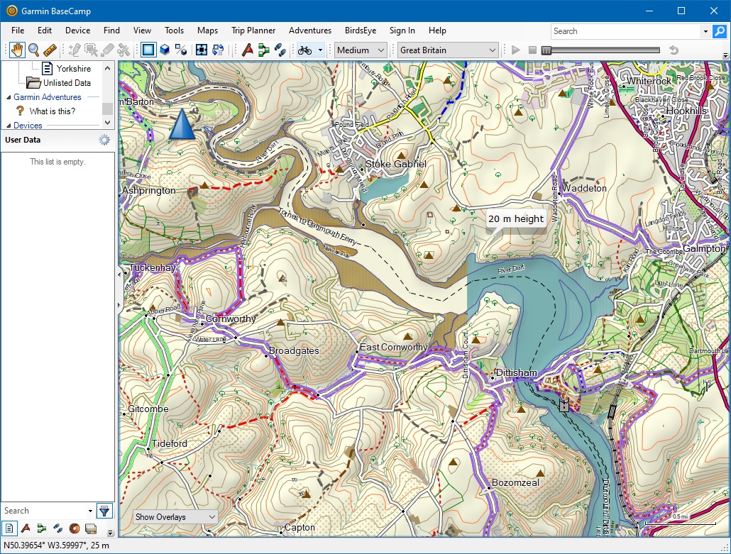
Have realised that the other tiles displaying error message also are not showing the sea correctly. The other tiles have narrow tidal inlets that are not being identified as sea - see attached. -----Original Message----- From: Mike Baggaley [mailto:mike@tvage.co.uk] Sent: 20 March 2020 07:35 To: 'mkgmap-dev@lists.mkgmap.org.uk' <mkgmap-dev@lists.mkgmap.org.uk> Subject: RE: [mkgmap-dev] Commit r4470: genSea.patch by Ticker Berkin Just noticed the log file has the following in it: 66973072.o5m: Adjacent coastlines hit tile edge in same direction 3.512082099914551 null 66973072.o5m: Adjacent coastlines hit tile edge in same direction 3.904301643371582 WAY: 4611686018492528634 null(50.39497375488281/-3.603515625) [] This is the offending tile, although there are other tiles showing the same message: 66973028.o5m: Adjacent coastlines hit tile edge in same direction 3.68414306640625 null 66973028.o5m: Adjacent coastlines hit tile edge in same direction 3.6845932006835938 WAY: 4611686018454067807 null(51.540770530700684/0.5712890625) [] 66973031.o5m: Adjacent coastlines hit tile edge in same direction 1.3157111273871527 null 66973031.o5m: Adjacent coastlines hit tile edge in same direction 1.5220565795898438 WAY: 4611686018456515937 null(51.62250280380249/0.5712890625) [] 66973063.o5m: Adjacent coastlines hit tile edge in same direction 0.964984130859375 null 66973063.o5m: Adjacent coastlines hit tile edge in same direction 0.968072509765625 WAY: 4611686018481807136 null(50.8447265625/-1.112666130065918) [] 66973064.o5m: Adjacent coastlines hit tile edge in same direction 2.0334129333496094 null 66973064.o5m: Adjacent coastlines hit tile edge in same direction 2.1257583618164064 WAY: 4611686018481855529 null(50.8447265625/-1.1539077758789062) [] 66973071.o5m: Adjacent coastlines hit tile edge in same direction 1.4875097274780273 null 66973071.o5m: Adjacent coastlines hit tile edge in same direction 1.493368148803711 WAY: 4611686018490569733 null(50.534770488739014/-3.603515625) [] 66973216.o5m: Adjacent coastlines hit tile edge in same direction 3.6122945149739585 null 66973216.o5m: Adjacent coastlines hit tile edge in same direction 3.6950721740722656 WAY: 4611686018642067673 null(54.13313627243042/-2.8125) [] 66973233.o5m: Adjacent coastlines hit tile edge in same direction 1.8426347620346966 null 66973233.o5m: Adjacent coastlines hit tile edge in same direction 1.9191019394818474 WAY: 4611686018657352840 null(54.21201467514038/-2.8125) [] Do these messages indicate errors in the coastline data? Regards, Mike -----Original Message----- From: Mike Baggaley [mailto:mike@tvage.co.uk] Sent: 19 March 2020 23:44 To: mkgmap-dev@lists.mkgmap.org.uk Subject: Re: [mkgmap-dev] Commit r4470: genSea.patch by Ticker Berkin Hi Gerd & Ticker, Whilst I was testing Ticker's patch, Gerd's update was committed, so I am slightly behind the times. Both the patch and the committed code have solved almost all my coastline problems. Thanks for your efforts. I now have no tiles that are being filled with sea, but I do have one tile that is now displaying the opposite problem, in that it now displays all land and no sea with both code versions, even though there is a significant amount of sea. Please see the attached screenshot. I would have attached the tile, but it is rather large for emailing. Cheers, Mike -----Original Message----- From: svn commit [mailto:svn@mkgmap.org.uk] Sent: 18 March 2020 18:23 To: mkgmap-svn@lists.mkgmap.org.uk; mkgmap-dev@lists.mkgmap.org.uk Subject: [mkgmap-dev] Commit r4470: genSea.patch by Ticker Berkin Version mkgmap-r4470 was committed by gerd on Wed, 18 Mar 2020 genSea.patch by Ticker Berkin fixes flooded areas caused by changes in r4392 and other issues with unclosed coastlines http://www.mkgmap.org.uk/websvn/revision.php?repname=mkgmap&rev=4470